Annular eclipse, Oct 14
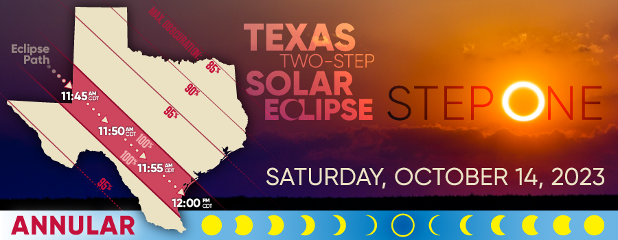
An annular solar eclipse will pass from Northwest to Southeast Texas on Saturday, October 14, 2023. The eclipse will begin its pass through in Andrews County and trend southeast, exiting the Texas coast around noon near Corpus Christi. During an annular eclipse, the sun forms a “Ring of Fire” around the moon as the moon’s shadow obscures the sun, but the moon appears slightly smaller than the sun. Eye protection must be worn at all times!
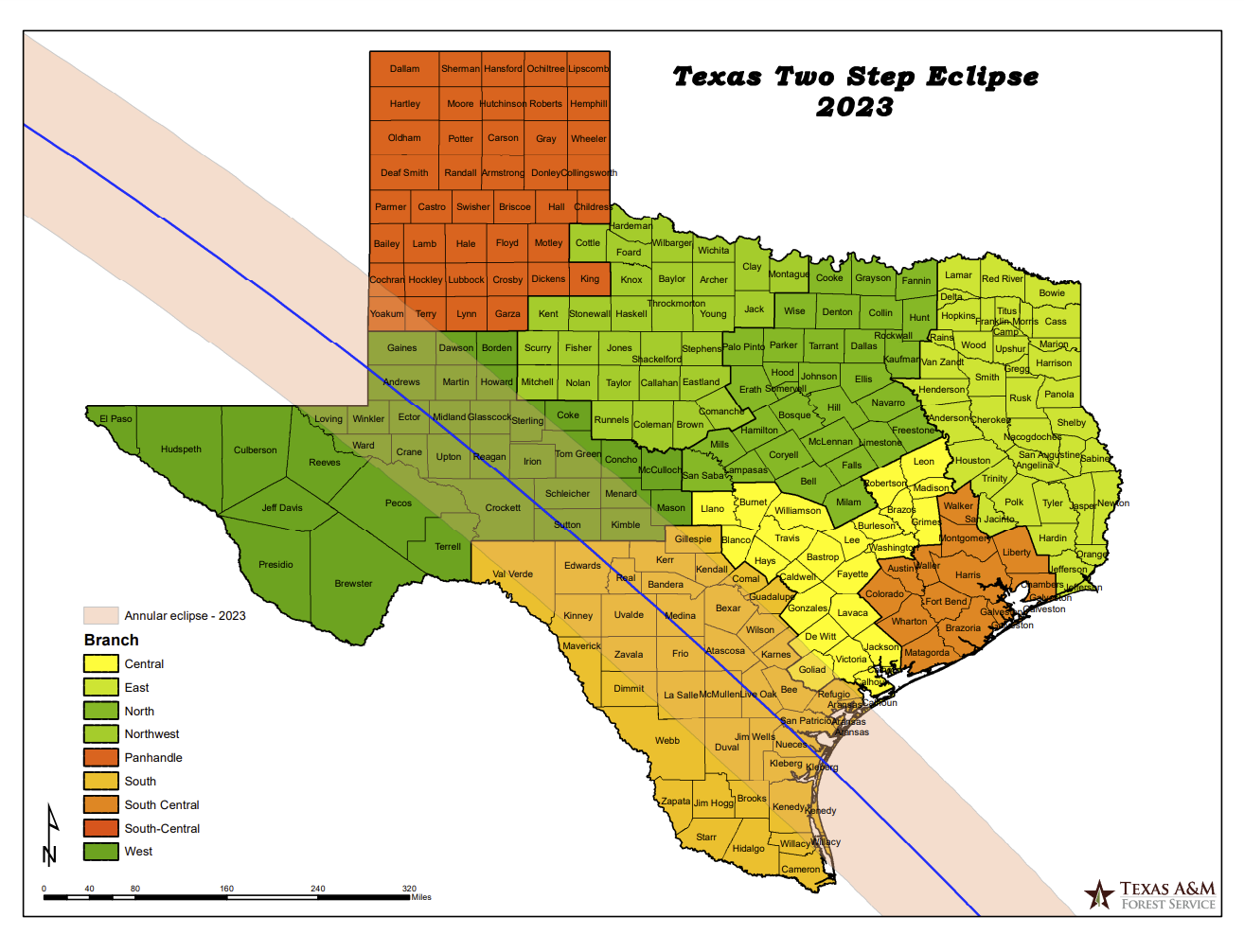
Referring to this map, the blue line will have the best viewing experience for the eclipse and the shaded path of annularity will see at least 90% obscuration. The longest viewing experiences will occur as the eclipse travels further towards the coast, with Corpus Christi having the longest experience at around 5 minutes.
- Experience the Texas Two Step Eclipse
- Enjoy the eclipse, recreate responsibly
- Enjoy the eclipse with these tips
- Enjoy the eclipse, practice responsible and respectful recreation
- Crush it! Drown it! Toss it! Or take it! Tread lightly, leave no trace
- When in doubt, know your route
- Be early and plan ahead
- Wildfire Prevention
- Avoid sparking a wildfire, do not park on dry grass
- Avoid sparking a wildfire, do not drag tow chains
- Avoid sparking a wildfire, do not drive with low tire pressure
- Don’t leave your campfire hot! Drown, stir, drown again and feel. Remember, if it’s too hot to touch, it’s too hot to leave
- Do your part and don’t let a wildfire start
- Protect Texas’ natural areas
- Use local firewood to avoid spreading invasive pests
- Burn it where you buy it
- Prevent oak wilt spread
- Eclipse
- Texas
- Enjoy the Eclipse
- Smokey Bear wildfire prevention
- Know before you go
- Practice responsible and respectful recreation
- Discover the Forest
- Texas A&M Forest Service
- https://tfsweb.tamu.edu/DailyFireDanger/
- https://tfsweb.tamu.edu/FireWeatherAndOutlooks/
- https://tfsweb.tamu.edu/ArsonHotline/
- https://tfsweb.tamu.edu/CurrentSituation/
- https://tfsweb.tamu.edu/ProtectYourRanch/
- https://tfsweb.tamu.edu/ProtectYourWildlands/
- https://tfsweb.tamu.edu/ProtectYourHome/
- https://tfsweb.tamu.edu/preventionresources/
- https://tfsweb.tamu.edu/BurnBans/
- https://texasoakwilt.org/oakwilt
- https://tfsweb.tamu.edu/arborday/
- Counties Affected Center Line
- Andrews
- Ector
- Midland
- Upton
- Reagan
- Crockett
- Sutton
- Edwards
- Real
- Uvalde
- Medina
- Frio
- Atascosa
- McMullen
- Live Oak
- San Patricio
- Nueces
- Gaines
- Dawson
- Martin
- Howard
- Winkler
- Loving
- Ward
- Crane
- Pecos
- Terrell
- Glasscock
- Sterling
- Irion
- Schleicher
- Kinney
- Maverick
- Dimmit
- Zavala
- Bandera
- Kerr
- Kimble
- Menard
- Tom Green
- Coke
- Concho
- Mason
- Gillespie
- Kendall
- Bexar
- Comal
- Guadalupe
- Wilson
- La Salle
- Webb
- Duval
- Jim Wells
- Karnes
- DeWitt
- Goliad
- Bee
- Refugio
- Aransas
- Kleberg
- Kenedy
- Brooks
- Willacy
- Cities within path of annularity
- Denver City
- Seminole
- Seagraves
- Andrews
- Odessa
- Midland
- Stanton
- Garden City
- Rankin
- Texon
- Big Lake
- Barnhart
- Mertzon
- Ozona
- Elderado
- Sonora
- Rock Springs
- Junction
- Leakey
- Concan
- Kerrville
- Boerne
- Pearsall
- San Antonio
- Floresville
- Three Rivers
- Karnes City
- George West
- Kenedy
- Beeville
- Mathis
- Alice
- Corpus Christi
- Kingsville
- Aransas Pass
- Rockport
- Port Aransas
- State Park/Natural/Historic Areas within Path of Annularity
- Albert & Bessie Kronkosky SNA
- Big Spring SP
- Choke Canyon SP - Calliham Unit
- Choke Canyon SP - North Shore Unit
- Choke Canyon SP - South Shore Unit
- Devils River SNA - Big Satan Unit
- Devils River SNA - Del Norte Unit
- Devil's Sinkhole SNA
- Garner SP
- Goliad SP
- Goose Island SP
- Government Canyon SNA
- Guadalupe River SP
- Hill Country SNA - Louise Merrick
- Unit
- Honey Creek SNA
- Kickapoo Cavern SNA
- Lake Corpus Christi SP
- Lipantitlan SHS
- Lost Maples SNA
- Monahans Sandhills SP
- Mustang Island SP
- Old Tunnel SP
- San Angelo SP
- South Llano River SP